Kilimanjaro Climb Shira Route 8 days

Description

Affordable Kilimanjaro Trek Shira 8 Days Safari Highlights

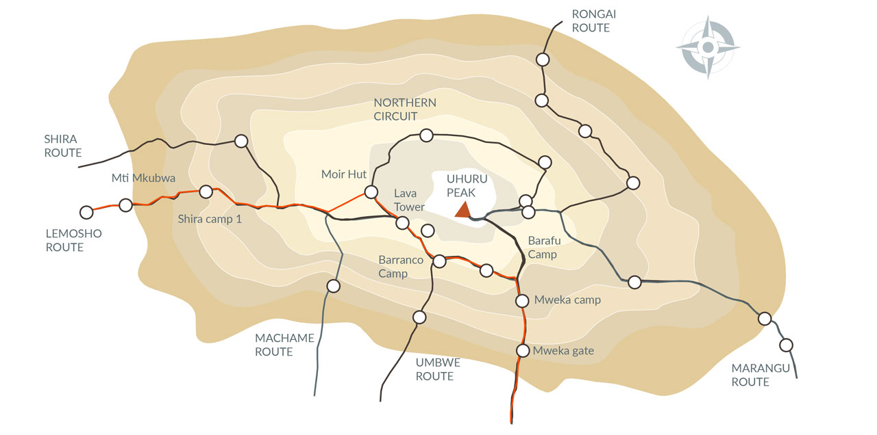
The Shira Route is a little used trail that begins near Shira Ridge. It is nearly identical to the Lemosho route. In fact, Lemosho is an improved variation of Shira, which was the original route. But because Shira starts off at high altitudes, it is less preferred over its successors by tourists even though it is a varied and beautiful route. Following this route, many trekkers have reported of having experienced altitude related problems on the first day itself while camping at 11,800 feet. Shria approaches Mount Kilimanjaro from the western side which begins with a long drive from Arusha to the Shira Ridge. The vehicle bypasses the rain forest zone and the hiking trail begins on Shira Ridge. The Shira route crosses the entire Shira Plateau from west to east in a pleasant, relatively flat hike. Then the route traverses underneath Kilimanjaro’s Southern Ice Field on a path known as the Southern Circuit before summiting from Barafu.

Detailed Itinerary

Kilimanjaro Climb Shira Route 8 days

Upon your arrival at Kilimanjaro Airport, our transfer driver will be waiting for you. He will take you to the Tulia hotel, where the rest of the day is at leisure. You might want to explore the town of Arusha (taxi required) or just relax at the lodge. In the evening you will be briefed by our team on site in preparation of the upcoming trekking tour. You will spend the night will do this briefing depend on your arrive time accommodation will be at https://www.tuliahotelandspa.com/

Accomodation: Tulia Boutique Hotel and Spa

We depart Arusha for Londorossi Gate, which takes about 4 hours; here we will complete entry formalities while guides and porters prepare equipment. We then continue to drive up a steep path to the Shira Gate where we will begin the hike. The trek starts through shrubs and giant heather until we reach Simba Camp.

Meal Plan: Full Board

Elevation: 11,800ft to 11,800ft

Distance: 4km / 2miles

Hiking Time: 1-2 hours

Habitat: Heath

Today is a fairly easy day to help with acclimatization. We begin by exploring the grassy moorland and volcanic rock formations on the plateau. Then we take a scenic path to the Shira Cathedral, a huge buttress of rock surrounded by steep spires and pinnacles, before settling at Shira 2 Camp.

Meal Plan: Full Board

Elevation: 11,800ft to 12,500ft

Distance: 6km / 4miles

Hiking Time: 2 hours

Habitat: Heath

We continue to the east up a ridge and then head southeast towards the Lava Tower – a 300 ft tall volcanic rock formation. We descend down to Barranco Camp through the strange but beautiful Senecio Forest to an altitude of 13,000 ft. Although you begin and end the day at the same elevation, the time spent at higher altitude is very beneficial for acclimatization.

Elevation: 12,500ft to 15,190ft

Distance: 7km / 4miles

Hiking Time: 4-5 hours

Habitat: Alpine Desert

Lava Tower to Barranco Camp

Elevation: 15,190ft to 13,044ft

Distance: 3km / 2miles

Hiking Time: 2-3 hours

Habitat: Alpine Desert

We begin the day by descending into a ravine to the base of the Great Barranco Wall. Then we climb the non-technical but steep, nearly 900 ft cliff. From the top of the Barranco Wall we cross a series of hills and valleys until we descend sharply into Karanga Valley. One more steep climb up leads us to Karanga Camp. This is a shorter day meant for acclimatization.

Meal Plan: Full Board

Elevation: 13,044ft to 13,106ft

Distance: 5km / 3miles

Hiking Time: 4-5 hours

Habitat: Alpine Desert

We leave Karanga and hit the junction which connects with the Mweka Trail. We continue up to the rocky section to Barafu Hut. At this point, you have completed the Southern Circuit, which offers views of the summit from many different angles. Here we make camp, rest and enjoy an early dinner to prepare for the summit day. The two peaks of Mawenzi and Kibo are viewable from this position.

Meal Plan: Full Board

Elevation: 13,106ft to 15,331ft

Distance: 4km / 2miles

Hiking Time: 4-5 hours

Habitat: Alpine Desert

Very early in the morning (around midnight), we begin our push to the summit. This is the most mentally and physically challenging portion of the trek. The wind and cold at this elevation and time of day can be extreme. We ascend in the darkness for several hours while taking frequent, but short, breaks. Near Stella Point (18,900 ft), you will be rewarded with the most magnificent sunrise you are ever likely to see coming over Mawenzi Peak. Finally, we arrive at Uhuru Peak- the highest point on Mount Kilimanjaro and the continent of Africa. From the summit, we now make our descent continuing straight down to the Mweka Hut camp site, stopping at Barafu for lunch. The trail is very rocky and can be quite hard on the knees; trekking poles are helpful. Mweka Camp is situated in the upper forest and mist or rain can be expected in the late afternoon. Later in the evening, we enjoy our last dinner on the mountain and a well-earned sleep.

Meal Plan: Full Board

Elevation: 15,331ft to 19,341ft

Distance: 5km / 3miles

Hiking Time: 7-8 hours

Habitat: Arctic

On our last day, we continue the descent to Mweka Gate and collect the summit certificates. At lower elevations, it can be wet and muddy. From the gate, we continue another hour to Mweka Village. A vehicle will meet us at Mweka Village to drive us back to the hotel in Arusha. Accommodation at https://www.tuliahotelandspa.com/ End of our Kilimanjaro Trek Shira Route

Meal Plan: Lunch on route either hot lunch or packed lunch

Elevation: 10,065ft to 5,380ft

Distance: 10km / 6miles

Hiking Time: 3-4 hours

Habitat: Rain Forest

Related Packages

Testimonial

Tourist Feedback

Affiliations

Signature Safari is partnered with following